(Ἑνα ελληνικὁ κεἱμενο βρἱσκεται στο κἁτω μἑρος της σελἱδας.)
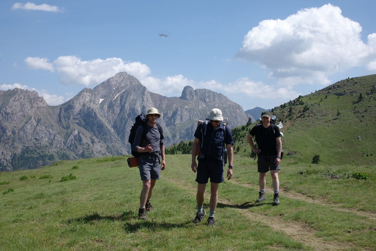
IF you are contemplating doing part or all of the route, you will need to do three things. 1) Acquire the most recent edition of the guidebook, Trekking in Greece: the Peloponnese and Pindos Way (Cicerone Press, 2018). 2) Check for updates either here (see the Contents list to the right of this page) or at https://www.cicerone.co.uk/ 3) Arm yourself with a GPS and the relevant Anavasi maps.
LATEST AND BEST NEWS
The Pindos part of the Peloponnese and Pindos Way has now teamed up with Terra Pindus (text available in Greek and English), a non-profit organisation dedicated to restoring the old paths that make up this route: clearing, repairing and waymarking them. The Pindos Way route itself is still as described in the Cicerone guide. Any updates, variations and/or improvements will be recorded under the heading Updates to the Pindos Way which is listed under Pages on the right of this Home page.
That said, the Pindos Way is entirely passable in its current condition – in spite of some tricky navigation in places – as friends who have completed the whole or parts already this season (2022) have reported.
The Peloponnese and Pindos Way
The mountains, which cover most of Greece, are among the loveliest and least developed in Europe, a real walker’s paradise. I first began to explore them in the 1970s when I was teaching in Athens. The seaside and island places that I had first known as a student in the 1960s had started to become “holiday destinations,” places where you went to lie in the sun and have a good time: a new type of product that people bought on the basis of an advertisement, a write-up in a brochure. Not what I was looking for: I wanted somewhere the “old” Greece still lived on.
A look at the map showed that the brownest, most roadless and least populated part of the country was the Pindos mountains. And then I came across an article in the journal of the Royal Geographical Society for September 1964 (vol 130, part 3) written by Lord Hunt of Everest fame, in which he described an expedition he had undertaken to the Pindos in 1963 with a party of young Greeks and English. Just what I was looking for! And I set off to follow my own route up the Pindos. Over the years it turned into a walkers’ guide, published by Cicerone Press. Since 2005 it has been a joint effort with Michael Cullen, who grew up in Greece and founded its first trekking company.
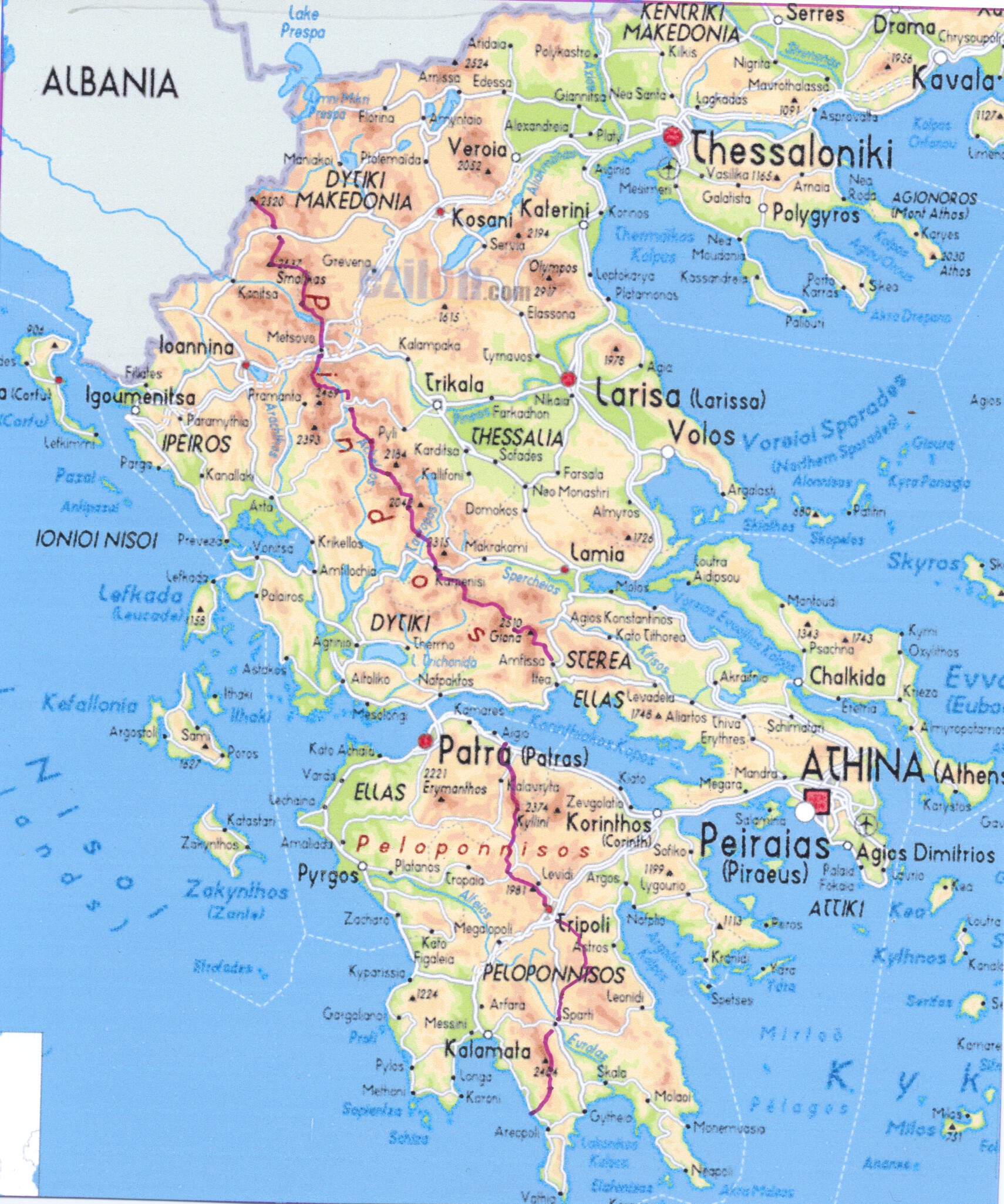
For the latest edition (2018, Trekking in Greece: the Peloponnese and Pindos Way), we decided to cut pretty much everything else and concentrate on creating this one long-distance route traversing the whole country from Albania in the north-west to the Mani in the south-east, the whole thing to be called The Peloponnese and Pindos Way.
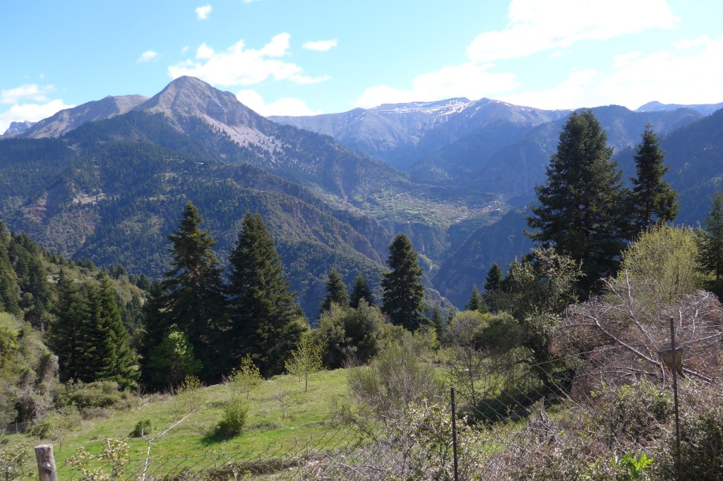
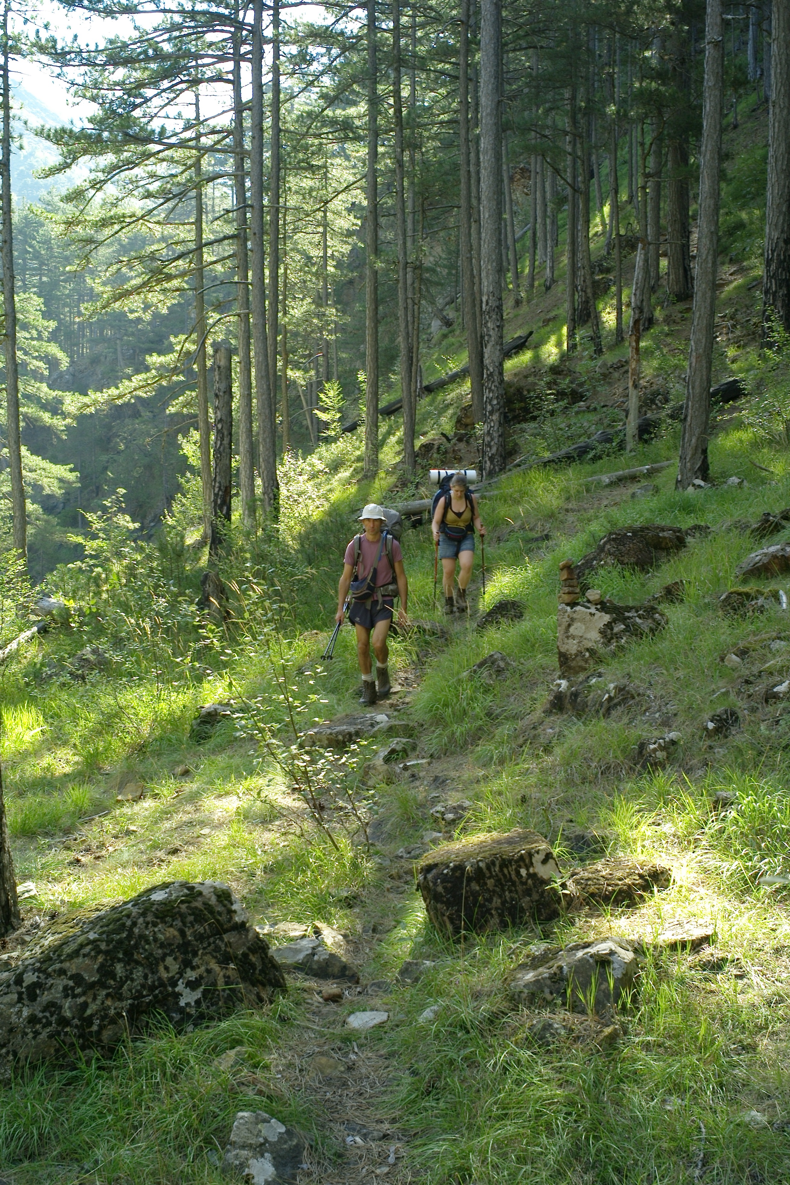
The Pindos Way, the subject of this website, follows the central mountain backbone of the Pindos range, from Albania to the Gulf of Corinth. The Peloponnese Way begins in the middle of the north shore of the Gulf of Corinth and cuts across the Peloponnese almost to Cape Tenaro, the most southerly point of the country and the second most southerly point in continental Europe. (See Michael’s The Peloponnese Way website for details.) The northern part is more Balkan in landscape and climate, the southern more Mediterranean, which also means that the hiking season between snowmelt and first snowfall is a month or so longer.
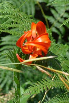
The landscapes will be a surprise to people who know only the seaside and islands of Greece: forests of beech, fir and pine, alpine meadows, numerous peaks above 2000m, rivers and waterfalls, remote and handsome stone-built villages, flocks of transhumant sheep, rich and varied populations of wildflowers and some big beasts, in the form of wolves and brown bears – though you will be lucky to catch a glimpse of these.
If you need further convincing, take a look at the website of Jane and Alan Laurie, in which they describe their epic walk from the Prespa lakes in the far north-western corner of Greece to the south of the Peloponnese. Their route, though they did the Píndos part in reverse, north to south, is pretty much the same as ours. It is a wonderfully fresh and evocative account of the landscapes they passed through and their adventures and encounters. See also Jane’s article for Cicerone Press.
You might also find my book The Unwritten Places interesting (available on Amazon); it tells the story of my first explorations of the Píndos in the 1970s. There is also a TV documentary called Dhiáva – The Autumn Journey that I made with David Hope about the Vlach shepherds of the northern Píndos and the autumn transhumant journey when they drive their flocks down to the lowlands for the winter (available on YouTube, with an additional 30mins video footage under the title Summer in Samarína). There is also a Greek language version that was shown on Greek TV in 2001.
TERRA PINDUS
But things have changed. A chance meeting with Apostolis Tsimpanakos in 2018 has led to the creation of a non-profit organisation, Terra Pindus (see above).
The goal is to bring the route up to the standard of, say, a French GR, have its existence officially recognised and then extend it to include substantial and beautiful variations especially to the west of the existing route. It is not something that can be achieved overnight. There is a lot of physical work involved, as well as diplomacy, in getting all the various state agencies like the Forestry Commission and local political authorities on board.
But the work is under way. The first 100km, sanctioned and sponsored by the demos (borough) of Delphi, will be “handed over” in the autumn of 2022, paths freshly dug, branches pruned, red and yellow striped waymarks at regular intervals. The work all done by volunteers: Bravo tous, as they say in Greek. Well done! See Updates to the Pindos Way on this website for a description of the newly completed first stage.
For a general view and the latest news on the work in progress, visit https://www.terrapindus.gr/list.php?c=activities&l=en (available in English and Greek). The site is full of wonderful photos that cannot fail to whet your appetite. Apostolis is now the main man.
DONATE!
WE NEED MONEY! If anyone would like to support this project, any contributions will be gratefully received. Go to the Terra Pindus website and click on the Donate button.
The paths exist but getting them back into working order requires painstaking physical labour. It would be a great help if we could afford to pay two or three wages. Up till now everyone has given their time free and that is obviously difficult for those in employment.
A FINAL WORD
I say Pindos, sometimes even Pindhos. Apostolis says Pindus. I say Way, he says Trail. It is a difference we will have to resolve, but rest assured: it is the same thing we are talking about and working on.

A little history
These routes are based on what remains of the incredibly dense network of footpaths connecting villages and hamlets and high summer sheepfolds that were the only roads in these mountains until modern times. Unmapped and known only to the locals, the mountains were more or less impenetrable to strangers. They became the natural resort and hideout of all manner of brigand, outlaw, and rebel, both against the Turkish overlords who ruled the land for centuries after their conquest of Constantinople in 1453, against German and Italian invaders in the Second World War and, in the case of Communist insurgents, against their own government in the 1940s. What we call the Pindos Way was known as the πορεια των ανταρτων, the Rebels’ Route.
The relative security of the mountains also allowed local traditions to flourish and trade to develop especially in the northern half of the Pindos inhabited by the shepherding clans of Latin-speaking Vlachs who sold their wool products as far away as Vienna and Odessa. The prosperity and industry of these people is visible in the legacy of churches and monasteries, cobbled roadways and bridges, and handsome architecture that they have left behind.
These mountain regions were as influential in shaping the character of modern Greece as the much better known islands and lowlands. Associated in recent times with hardship and poverty, they have been dismissed as useless, αχρηστα, and largely ignored. and disdained. It is time their dignity and important place in Greek history were restored.
I believe the construction of this trans-Pindos hiking route should be seen as a kind of archaeology as well as a wonderful recreational resource in these difficult times, especially for city populations exposed to all the stresses of crowded and noisy environments, the tyranny of computer screens, social media and life online. The educational value is clear, both in a revaluing of a large part of Greece’s popular history and in re-introducing people to the possibilities of different ways of life that respect the natural world. It was very encouraging recently to see some schools in the Amfissa area taking their pupils for a day out on the paths.
One of the great walks of the world
In 1988 John Cleare, a well-known English mountain photographer and climber, published a book called Trekking: Great Walks of the World, to which I was asked to contribute a chapter about the Pindos mountains: The Rocky Spine of Greece: the PindosTraverse, which described pretty much exactly The Pindos Way.
The Peloponnese and Pindos Way does indeed deserve to be ranked among the great walks of Europe. So, walkers of the world, let us get out there and make sure it is so ranked. Walk it, mark it, sing its praises, spend some money in the villages.
And there is money in it
Statistics from countries that keep reliable records of such matters show that well-known routes bring substantial amounts of money into rural communities with few other sources of revenue.
For example, the Robert Louis Stevenson Way in France was walked by 6,140 hikers in 2012, who spent €2.9 billion in the local economy in that one season. The Chemin de Saint Jacques (GR65) in France sees 20,000+ walkers every year, with an average daily budget of €50 euros spent in villages with little other source of income. The Spanish section sees over 200,000 visitors. God knows how much they spend.
My friend Kate Clow’s Lycian Way in south-west Turkey has earned its substantial reputation in just twenty years. At first, the local peasantry scratched out the waymarks, riddled the signs with bullet holes…but that did not stop the crazy foreigners. They kept coming, close to 30,000 a year, bringing their much-needed money. Now the locals open guesthouses (getting on for 100), stock the village shops with walkers’ necessities…
In Greece it will be the same. Guesthouses will open. Villagers will take on the responsibility of keeping their sections of path open. 100, let alone 500, walkers a season would make a significant difference to the economy of remote villages in the Pindos and facilities would quickly improve.
Το Πἑρασμα της Πελοποννἡσου και της Πἱνδου
Ο ορειβατικὁς οδηγὁς, The Mountains of Greece, που πρωτοβγἡκε το 1986, θα κυκλοφορἡσει στις 15 Μαρτιου 2018 με το τἱτλο Trekking in Greece: The Peloponnese and Pindos Way (Tim Salmon and Michael Cullen, Cicerone, Oxenholme Rd, Kendal LA9 7RL, UK).
Πως ξεκἱνησε το ἑργο
Πρωτοπἡγα στην Ελλἁδα το Πἁσχα του 1958 μαθητἡς λυκεἱου. Γοητἑυτηκα και ορκἰστηκα να γυρἱζω ὁσο πιὁ σὐντομα μποροὐσα. Και ἑτσι ἐκανα. Κἁθε καλοκαἱρι που ἡμουνα φοιτητἡς πανεπιστημἱου κατἑβαινα με ωτοστὁπ. Γὑρισα και πἁλι μετἁ το πανεπιστἡμιο και βρἡκα θἑση σα καθηγητἡς στην Κρἡτη.
Τη διἀρκεια της Χοὐντας ἡμουν στο Λονδἱνο στη γειτονιἁ του Camden Town, ὁπου εἱχαν εγκαταστηθεἱ οι περισσὁτεροι Κὑπριοι πρὁσφυγες και βρἡκα στη δημὁσια βιβλιοθἡκη ἑνα βιβλἱο, Τα Ελληνικἁ Βουνἁ, που διηγιὁταν τις ορειβατικἑς εκδρομἑς κἀποιου ορειβἁτη. Λἱγο μετἁ διἁβασα σ᾽ἑνα τεὑχος του περιοδικοὑ Journal of the Royal Geographical Society ἑνα ἁρθρο του Lord Hunt, αρχηγοὑ της πρὡτης Βρεττανικἡς αποστολἡς που κατἑκτησε την κορυφἠ του Ἑβερεστ, ὁπου περιἑγραφε μἱα εκδρομἡ που εἱχε κἁνει τον Απρἱλιο του 1963, με μἱα ομἁδα νεαροὑς, οι μισοἱ Ἑλληνες, οι μισοἱ Ἁγγλοι, που ξεκἱνησε απὁ την Ἁμφισσα και διἁσχισε ὁλη την Πἱνδο μἑχρι την Καστοριἁ. Με ενἑμπνευσε και πἠρα την απὀφαση να ξεκινἡσω και εγὡ με την πρὠτη ευκαιρἱα. Και αυτὀ ἑγινε το ῾76-77.
Χἁρτες δεν υπἡρχαν
Χἁρτες μεγἁλου κλἱμακος δεν κυκλοφοροὑσαν τὁτε. Ἑπρεπε να ρωτἁω απὁ χωριὁ σε χωριὀ. Στην επαρχἱα ο ἁσφαλτος ἑλειπε τελεἱως σε πολλἑς περιοχἑς. Παρ᾽ὁλο που ο κὁσμος εἱχε ἡδη λιγοστἑψει στα χωριἁ και αυτοἱ που ἑμειναν δεν κυκλοφοροὑσαν πιἁ με τα πὁδια, θυμὁντουσαν με ακρἱβεια που πἑρναγαν τα μονοπἁτια και μου το εξηγοὑσαν με μεγἁλη υπομονἡ. Υπἡρχαν ακὁμα τα τελευταἱια στοιχεἱα της παραδοσιακἡς ζωἡς – λἱγες καλλιἑργιες με αυλἁκια που κατἑβαζαν νερὁ για πὁτισμα απὁ ψηλἁ, νερὁμυλοι, ταχυδρὁμοι που τριγὑριζαν στα χωριἁ με ζὡα, καρβουνἁριδες και ξυλοκὁποι που δοὑλευαν στο δἁσος, χορτἁρια για τα ζὡα θερισμἑνα με δρεπἁνι…. Ζωἡ δὑσκολη για τους ντὁπιους. Για μἑνα σκἑτη μαγεἱα.
Ὁσο προχωροὑσα μἑσα στα βουνἁ και ανακἁλυπτα τις ομορφιἑς τους – τα ατελεἱωτα δἁση με ἑλατα και οξιἑς, ποτἁμια και φαρἁγγια, μἑρη απἁτητα απὁ κἁθε μορφἡς ὁχημα, ξὑλινα γεφὑρια, πετρὁκτιστα χωριἁ, μεσαιωνικἁ μοναστἡρια κρεμασμἑνα σε απἱστευτους γρεμνοὑς, καλντερἱμια, λιβἁδια γεμἁτα αγριολοὑλουδα την Ἁνοιξη – διαμορφὡθηκε μἑσα μου η ιδἑα να γρἁψω κἁτι και εγὡ για τα ελληνικἁ βουνἁ, ἑναν ορειβατικὁ οδηγὁ που θα τραβοὑσε ορδἑς ορειβατὡν!
H καινουῥγια ἑκδοση
Το 1986 βγἡκε στο φως η πρὡτη ἑκδοση του The Mountains of Greece. Οι ορδἑς ορειβατὡν που περἱμενα δεν παρουσιἁστηκαν! Ἑτσι, με την πἑμπτη ἑκδοση που βγαἱνει τὡρα, ἁλλαξαμε κἁπως πλὡρη. Τὡρα εἱμαστε δὑο, εγὡ και ο φἱλος, Michael Cullen, o οποἱος γεννἡθηκε και μεγαλὡσε στην Ελλἁδα και ἡταν ἑνας απ᾽αυτοὑς που ιδρὑσαν την εταιρἱα Trekking Hellas. Με παρἁδειγμα το δἱκτυο GR στη Γαλλἱα, αποφασἱσαμε να συγκεντρωθοὑμε στην χἁραξη μἱας μεγἁλης πεζοπορικἡς διαδρομἡς που θἁ διἁσχιζε ὁλη την ορεινἡ ραχοκοκκαλιἁ της Ελλἁδας απὁ την κορυφἡ του Γρἁμου πἁνω στα Αλβανικἁ σὑνορα μἑχρι τις ἑσχατες παραλἱες της Μἁνης κἁτω στην Πελοπὁννησο. Στα αγγλικἁ την ονομἁσαμε The Peloponnese and Pindos Way. Στα ελληνικἁ μπορεἱ να αποδοθεἱ ως Η Διἁσχιση της Πελοποννἡσου και της Πἱνδου. Δεν μου φαἱνεται ὁμως και πολὑ πιασἁρικο σαν ὁνομα. Το πρὁβλημα στα ελληνικἁ εἱναι ὁτι οι λἑξεις ἑχουν πἁρα πολλἑς συλλἁβἑς! Για το τμἡμα της Πἱνδου σκεφτὁμουνα να το αποκαλἑσω Το Πἑρασμα της Πἱνδου. Για την Πελοπὁννησο ὁμως δεν μου ἑρχεται ἑμπνευση. Εἱμαστε ανοικτοἱ για προτἁσεις…
Σε πἁνω απὁ τριἁντα χρὁνια ο Michael και εγὡ ἑχομε περπατἡσει σε βουνἁ πολλὡν ἁλλων χωρὡν, μἑχρι στο Νεπἁλ και στο Τατζικιστἁν. Πιστἑυομε ὁτι η διαδρομἡ αυτἡ αξἱζει να καταταχθεἱ ανἁμεσα τις ομορφὁτερες πεζοδρομικἑς διαδρομἑς της Ευρὡπης. Πἑρα απ᾽αυτὁ οι περιοχἑς που περνἁει η διαδρομἡ εἱναι βαθιἁ δεμἑνες με τις πιὁ σημαντικες παραδὁσεις και αξἱες και γεγονὁτα που ἑδιναν στην Ελλἁδα το χαρακτἡρα της. Αποτελοὑν ἑνα σημαντικὁ μἑρος της κληρονομιἁς της πατρἱδος.
Για να γἱνει ὁμως γνωστἡ στους κὑκλους των διεθνὡν ορειβατὡν πρἑπει να βγοὑμε να τη πατἡσομε! Σκἑφτομαι το Lycian Way η Likya Yolu στην ΝΔ Τουρκἱα, που την δημιοὑργησε μἱα φἱλη μου αγγλἱδα, η Kate Clow, το 2001. Στην αρχἡ οι ντὁπιοι, καχὑποπτοι, πυροβὁλησαν και ἑριξαν κἁτω τις ταμπἑλες. Τὡρα, που κατἁλαβαν ὁτι το περπἁτημα αρἑσει σε ξἑνους με λεφτἁ, προσἑχουν τα μονοπἁτια και δεν προλαβαἱνουν να ανοἱγουν ξενὡνες. Για να πἁρει τη σωστἡ θἑση της στην πανοπλἱα των Ευρωπαἱïκων ορειβατὡν The Peloponnese and Pindos Way χρειἁζεται βἁση ελληνικἡ, κυκλοφορἱα αρκετἡ για να πεἱσει τους ντὁπιους και τους τοπικοὑς ορειβατικοὑς συλλὁγους ὁτι αξἱζει ο κὁπος να συντηρἡσουν τα μονοπἁτια τους.
Ορειβἁτες και φυσιολἁτρες της Ελλἁδας ενωθεἱτε και ξεκινἡσετε!