(Ἑνα ελληνικὁ κεἱμενο βρἱσκεται στο κἁτω μἑρος της σελἱδας.)
North of Mesokhóra the country is bigger and wider. You leave behind the close, tight-grained topography of the Ágrafa for higher and wider uplands. It is also the beginning of Vlach territory.
The Greek Vlachs today think of themselves as Greek, although strictly speaking they must be an ethnic minority. From time immemorial they have been transhumant shepherds, owning no land but spending the winters in the lowlands and bringing their flocks to the mountains in the summer. There have been other Vlach communities in the Balkans, but the Greek ones have had their own exclusively Vlach villages in the northern Píndos at least for several centuries and their mother tongue which is clearly of Latin origin and closely related to Romanian is full of Greek loan words. It is the language which until today has been their really distinguishing feature. If you know any Latin or Italian you will soon spot familiar-sounding words like cane for dog, pene for bread, apa for water, lupu for wolf, calu for horse, casa house, frate brother and so on. Like Welsh and Irish, it is dying out. The youngsters understand it but tend to use Greek together, the language of school, TV, the internet (yep, that too has arrived in the remotest corners of the Píndos) and youth culture. Until the 1960s these were out-of-the-way places and it was easy to avoid going to school much beyond 10. They lived within their own Vlach-speaking communities. When I first encountered Vlachdom it was still noticeable that the older women, who had very little contact with the outside non-Vlach world spoke Greek with a foreign accent.


Gardhíki was the first place I ever heard Vlach spoken. It is a big sheep-herding village on the west flanks of the Akhelóös valley four to five hours upstream from Mesokhóra. It is an easy-going hike, on riverside tracks, first on the east bank as far as the tiny hamlet of Fortósi, then on the west. There used to be a bent-tree bridge at Fortósi; now you have to ford, but the water is unlikely to be more than knee-deep. And always, incidentally, with these river crossings the water is so clear you can see exactly what is in front of you.


At the next village after Gardhíki you leave the Akhelóös/Aspropótamos valley to climb more than 1000 metres up and over the northern end of the Kakardhítsa ridge only to lose all the height gained immediately in the descent to Matsoúki.
A day later you are in Kalarítes, one of the most perfect surviving Vlach villages. It was also one of the most renowned and richest, its particular wealth coming from the workshops of its jewellers (there is a small museum in the village), the most famous of whom was a certain Bulgari, founder of the modern firm. But wool was the principal source of Vlach wealth (Siráko, the neighbouring village, for example, supplied the serge that made the capes of Napoleon’s navy) and in trading it they also became the hauliers of their time, their convoys of pack animals trading way up into the Balkans. And with this wealth they built some of the finest villages in Greece, for the most part largely deserted now.


Today the tarmac, which was meant to usher in the modern age, brings a few tourists. In the old days, to reach the village you had to climb the last hundred metres or so from the ravine bottom on a wonderful zigzagging cobbled stairway. I remember labouring up, lungs on fire, as lightning split the gathering dark as I tried to make the village before I was drenched by the breaking storm.
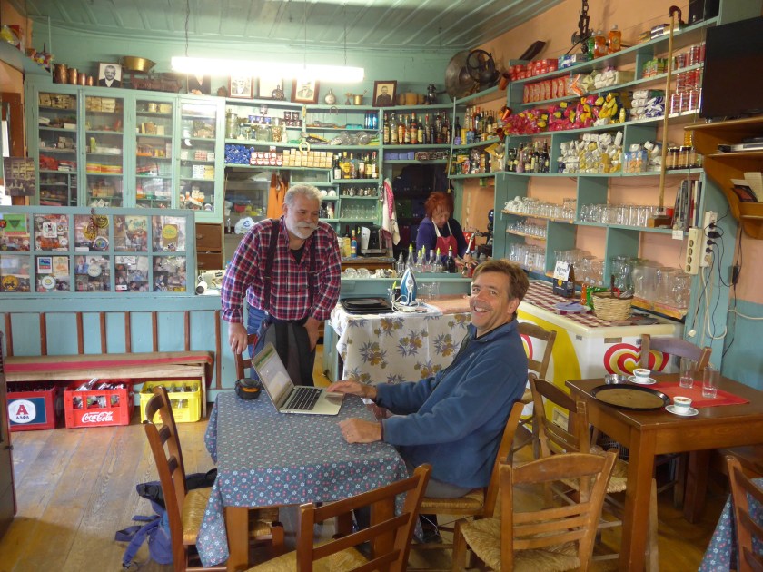
Again, one of the chief pleasures of the place is a café/magazeé just above the square, run by Napoléon Zánglis and his wife. It is a real period piece; he has preserved it just as it was in his father’s day. He is a real advocate for the traditional charms of the place. He runs a very attractive guesthouse a couple of minutes’ walk away. The food is good. He sings as a cantor in the church and there is often an informal singsong in the café at night.


There is a great sweep of summer pastures above the village leading up to the Báros col, where I saw a bear and her cub last July, and the Mégas Trápos ridge. The old road for Khalíki, the next big Vlach sheep village to the north, goes up through the pastures (watch out for the dogs) and over the pass at Tris Pírghi, but there is also a great ridge walk, airy but not dangerous, leading to the 2294m summit of the Peristéri massif followed by a long descent through the deepening valley formed by the streams that rise on Peristéri.


As you approach the village you pass the remains of orchards and terraced fields where once the villagers undertook some cultivation: abandoned here as everywhere else nowadays.


Khalíki too is a handsome village of solid stone houses, though not of the same rank as Kalarítes, with several rather beautiful churches in the vicinity. It lies right on the banks of the Akhelóös/Aspropótamos, here, close to its sources, no wider than a stream. It used to be full of tasty little brown trout, but over the years people have netted or dynamited them and the population has been decimated. The square is large and, in summer, lively, with several magazyá, where everyone gathers.


There is another really nice guesthouse (ksenónas in Greek), which also serves meals, on the northern edge of the village overlooking the bridge where the road from the villages of the Aspropótamos to the south comes in. There is also plenty of space to camp by the river.
We have been trying to persuade the local authorities that walkers – all outsiders are seen as toorístes – are a good thing: they bring money. But you run into the boneheaded resistance of the old-timers, who think even walkers are ‘newfangled’: “They frighten the sheep.” Somewhat less than bears, one might think!


And from here to the fleshpots of the great metropolis of Métsovo is just another day. Don’t take the tarmac. With patience and a little care, for most of the way you can still find the old path up to the pass at Hodja’s ridge – ee rákhee too hódza, presumably some long forgotten Ottoman landowner. From there you cut down to Hodja’s sheepfold – ee stánee too hódza– and join a rough shepherd’s track that sticks close to the line of the old path down into the valley of the river Rónas where you join the narrow tarmac road along its further flank that leads first into the village of Anílio and thence across a steep ravine into what is pretty much the capital of Greek Vlachdom, Métsovo.


It is a pretty old town still with partly cobbled streets and stairways and some handsome buildings. There are shops, tavernas, hotels; it is on the tourist route. There are good transport connections to the outside world and it is actually on the newish Odhós Egnatías autoroute to Kozáni and Thessaloniki.
Τμἡμα 3 – Μεσοχὡρα-Μἑτσοβο
Απὁ δω και πἁνω τα τοπἱα γἱνονται πιὁ μεγαλοπρεπἡ, πιὁ ογκὡδη και γυμνἁ στα υψὡματα. Μπαἱνομε στην πατρἱδα των Βλἁχων που ακὁμα, αν και λιγὁτεροι παρἁ παλαιἁ, συνεχἱζουν και ανεβαἱνουν τἑλος Μαἱου με τα κοπἁδια απὁ τα διἁφορα χειμαδιἁ τους στον κἁμπο της Θεσσαλἱας και εγκαθἱστανται για το καλοκαἱρι στα εἱκοσι τἑσσερα χωριἁ τους στον Ασπροπὁταμο και στη Βὁρεια Πἱνδο. Ὀπου και να πας στα υψὡματα μἑχρι τον Οκτὡβριο θα συναντἁς η τουλἁχιστο θα ακοὑσεις κουδοὑνια κοπαδιὡν. Μὁνο να προσἑξετε τα τσομπανὁσκυλα. Μην μπἡτε ποτἑ μἑσα στα πρὁβατα οὑτε μἑσα σε στροὑγκα χωρἱς ἁνθρωπο εκεἱ να μαζἑψει τα σκυλιἁ. Το ρὁλο τους εἱναι να προστατἑψουν τα προβατἁ απὁ αρκοὑδες, λὑκους και ληστἑς. Απὁ χἁδια δεν ξἑρουν τἱποτα! Το καλὑτερο εἱναι να μεἱνατε ὁσο μακρυἁ μπορεἱτε. Στη περἱπτωση που ορμἁνε να αμυνθεἱτε με μπαστοὑνι και πἑτρες και να απομακρὑνεσθε ὁσο πιὁ γρἡγορα μπορεἱτε.
Την πρὡτη μἑρα απὁ τη Μεσοχὡρα ακολουθἁμε την ὁχθη του Ασπροπὁταμου, ὁπως λἑνε τον Αχελὡο εδὡ, μἑχρι το χωριὁ Γαρδἱκι ὁπου ἱσως να ακοὑσετε κἁτι γἑρους να μιλἁνε βλἁχικα αναμεταξὑ τους. Απὁ κει αρχἱζομε και ανεβαἱνομε να περἁσομε την βὁρεια προἑκταση της κορυφογραμμἡς της Κακαρδἱτσας. Κατεβαἱνομε Ματσοὑκι, περνἁμε Καλαρὑτες μἑσω την ωραἱα μονἡ Βἱλιζας. Το μονοπἁτι ἑχει φτιαχτεἱ τα τελευταἱα χρὁνια.
Οι Καλαρὑτες εἱναι υπἑροχο χωριὁ, μαζἱ με το γειτωνικὁ Συρρἁκο. Μη χἁσετε το μαγαζἱ του Ναπολἑωντα Ζἁγκλη που το ἑχει συντηρἡσει στο γνἡσιο παλαιὁ στυλ ὁπως ἡταν την εποχἡ του πατἑρα του και το ωραἱο φαγητὁ και το ψωμἱ φτιαγμἑνο με προζὑμι απὁ το Ἁγιον Ὁρος που κρατἁει ἡδη πἁνω απὁ 150 χρὁνια. Ἑχει και δωμἁτια.
Απὁ Καλαρὑτες βἁζομε πλὡρη για το Χαλἱκι, το επὁμενο βλαχοχὡρι προς τα βὁρεια. Εἱμαστε εδὡ στα σπανἁ. Στην αρχἡ ακολουθἁμε το χωματὁδρομο που πἁνε οι τσομπἁνοι για τη τοποθεσἱα Κουρκοὑμπετα. Μετἁ μἱα ὡρα κὁβουμε ΝΑ απὁ το Μαντρἱ και πἁλι πἑφτουμε σε ανὡμαλο χωματὁδρομο που πἁει για την τελευταἱα στροὑγκα στο Βαλτονἑρι – Μουτσιἁρα στα βλἁχικα – απ῾ὁπου ανεβαἱνεις στη ρἁχη και το διἁσελο του Τρεις Πὑργοι (πἑσανε τὡρα) που γυρνἁς κἁτω στη κοιλἁδα του ρἑματος που στο Χαλἱκι ενὡνεται με τον Ασπροπὁταμο. Η γραμμἡ του αιὡναιου μουλαρὁδρομου διακρἱνεται ακὁμα στο χορτἁρι. Φτἁνεις στη στροὑγκα Στουρνἁρα. Μην παἱρνεις το δρὁμο. Το μονοπἁτι συνεχἱζει ακριβὡς κἁτω απὁ τη στροὑγκα, μπαἱνει στα ἑλατα και σε βγαζει κἁτω στο ποτἁμι κοντἁ στο Χαλἱκι (ξενὡνας La Casaria στην βὁρεια ἁκρη του χωριοὑ.)
Φεὑγοντας για Μἑτσοβο ἑχεις την εντὑπωση ὁτι δεν υπἁρχει ἁλλη λὑση πἁρα τον ἁσφαλτο. Λἁθος, ὁπως ανακἁλυψα. Το παλαιὁ το μονοπἁτι υπἁρχει ακὁμα μἑχρι τη ρἁχη του Χὁτζα. Το καθαρἱσαμε πρὁχειρα πἑρυσι. Ξεκινἁει λἱγα μἑτρα μετἁ το ξενὡνα. Μπαἱνεις δεξιἁ στο δρομἁκι που ακολουθἁει το ποτἁμι. Στο τἑρμα, βρἱσκεται ἑνα μαντρἱ και μἱα μεγἁλη ιτιἁ αριστερἁ απὁ το δρὁμο. Ανεβαἱνεις την πλαγιἁ αριστερἁ και σε 30μ πἑφτεις στα χνἁρια του μονοπατιοὑ. Στρἱβεις δεξιἁ, περνἁς μἱα σαρα, ἑνα ρεματἁκι, ανεβαἱνεις μἱα σκἁλα βραχὡδη, βγαἱνεις σε μἱα πλαγιἁ που ἑχει γεμἱσει θἁμνους απὁ τὁτε που πρωτοπἑρασα πριν απὁ 50 χρὁνια. Πἑφτεις στον ἁσφαλτο για 100μ, ξαναμπαἱνεις στο μονοπἁτι, περνἁς τον ἁσφαλτο σε μἱα στροφἡ με εικὁνισμα και ανεβαἱνεις πἁλι στο μονοπἁτι παρἁλληλα στο δρὁμο μἑχρι τη ρἁχη του Χὁτζα. Ο ἁσφαλτος φεὑγει δεξιἁ για Μἑτσοβο. Εσὑ θα πας κατευθεἱαν κἁτω σε ἑνα λοὑκι και βγαἱνεις σε λειβἁδι με το μαντρἱ του Χὁτζα μπροστἁ σου. Εκεἱ πἑφτεις στο χωματὁδρομο που εξυπηρετεἱ τους τσομπἁνους και σε βγἁζει κἁτω στο ποτἁμι Ρὁνα και στο δρὁμο που πἁει για Ανἡλιο. Εκεἱ στο μαγαζἱ Το Πλατἁνι στρἱβεις κἁτω στη κοιλἁδα του Μετσοβἱτικο, περνἁς απεναντἱ στο μοναστἡρι του Αγ Νικὁλαου και ανεβαἱνεις στη κεντρικἡ πλατεἱα του Μετσὁβου (ξενοδοχεἱα, τρἁπεζα, μαγαζιἁ, συγκοινωνἱα).
