(Ἑνα ελληνικὁ κεἱμενο βρἱσκεται στο κἁτω μἑρος της σελἱδας.)
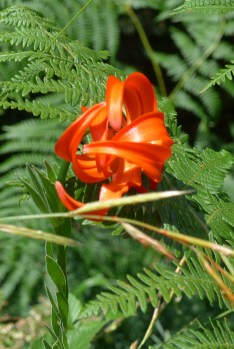
The stretch of country north of Karpenísi is known as Ta Ágrafa in Greek, which means roughly the “unwritten” or “unrecorded” places: unrecorded, so legend has it, in the tax documents of the Ottoman Turkish administration because it was too inaccessible and therefore dangerous for their officials to enter and control. When I first visited it in the 1970s, the central part of it was still without roads. The furthest villages were a day or two on foot from the nearest road. Their populations were permanent, but there was a summer population of transhumant shepherds who came up with their flocks from the lowlands and camped out all summer high in the mountain pastures. They were Sarakatsáni, whose Greek dialect is thought to be one of the most ancient, in contrast to their great rival shepherd clan, the Vlachs, who inhabit the more northern reaches of the Píndos and whose native tongue is basically a dialect of Romanian, although nobody knows how they came to inhabit a region so far from any other Romanian-speakers. They had their own proper villages in the mountains, whereas the Sarakatsáni were always hut-dwellers (see the pictures below).
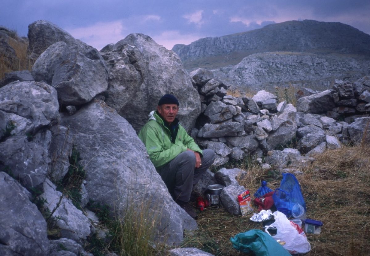
Once, sheltering from the snow in a hollow tree, I heard the sound of hooves approaching. It was the region’s postman with his two mules. It took him four days, he told me, to do his rounds. The paths – who knows how old: as old as the first settlement of the region – were the roads, beautifully banked with stone in the tricky places and ribbed on the steep bits with stones set upright to provide purchase for the feet of laden pack animals. The streams were all bridged with narrow arched bridges or tree trunks half cut through and bent to meet over the water; in some places there were karoúlia, cages or platforms suspended from pulleys, for pulling yourself across when the water was too high to ford. It was a world already fading, as so many people emigrated to the cities of Greece and abroad, but a world that had changed little over many centuries.
Before the roads came:


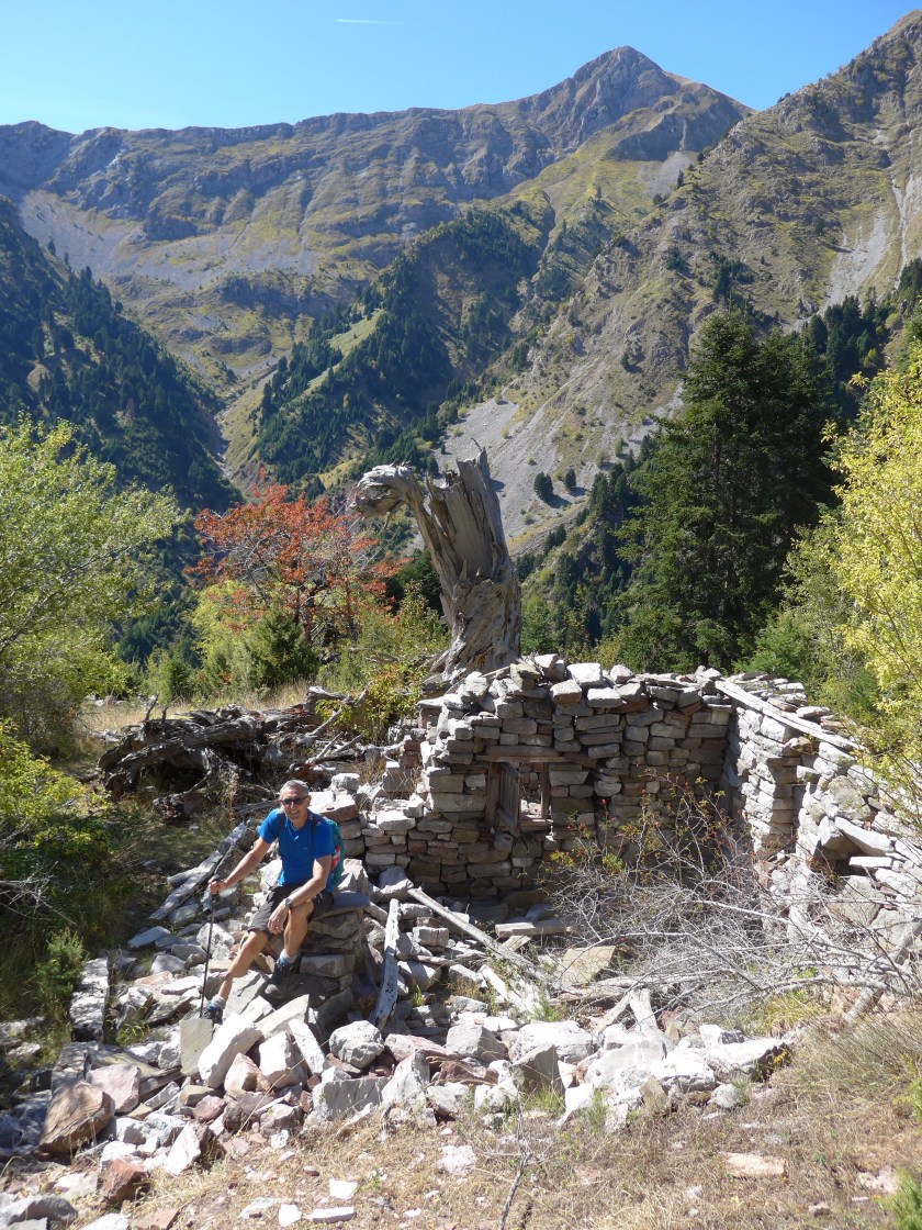
The terrain throughout the Ágrafa region is difficult. It is steep, friable and cut by numerous deep and narrow ravines, mostly thickly wooded with evergreen oak, plane trees and, higher, up to the tree line around 1800m, with Greek fir, abies cephalonica. The river Agrafiótis drains the middle; the Akhelóös, one the country’s principal rivers, drains the west and the Mégdhovas the east. Tiny villages perch wherever there is ground level enough to perch on, most of them now almost deserted, which does not prevent them from being extremely hospitable, especially to foreign walkers. In addition to the main villages, there is an amazing number of minute hamlets, sometimes only two or three cabins, tucked away in the wildest and most improbable spots. They are all abandoned now; you pass their ruins as you follow the old paths. You occasionally meet people who spent their earliest years in such places. They seem to us outsiders the epitome of rural idyllic and perhaps in some ways they were, but, as an English friend who has spent a lifetime in Greece and knew these places as long ago as 1950, when the Civil War had only just ended, warns me: life was primitive and harsh, there was little to eat and traditional values were particularly hard on women and girls. But it certainly sets the imagination going to think what life in such places must have been like.
North from Karpenísi
It takes a day or so to reach what I regard as the real beginning of Ágrafa, at the village of Kerasokhóri, close to the rim of the long deep gorge of the Agrafiótis river. It is a long day’s walk on the so-called E4, a trans-Europe hike that starts in Portugal and ends, somewhat improbably, in Cyprus! Most of the Greek part – with the exception now of the Peloponnese which Rolf Roost and George Kanellopoulos have resurrected and which forms a large part of our Peloponnese and Pindos Way – is not worth bothering with. But things change: someone has upgraded this stretch. The signage is followable, the tarmac bits are no more than a little used country lane and the country is magnificent, along and across the wooded valley of the Mégdhovas with the peak of Veloúkhi always looming on the eastern skyline.


For the first day out of Kerasokhóri you follow a shepherds track high in the fir forest on the east flank of the Agrafiótis gorge. The old mule trail that followed the valley bottom was sadly destroyed by the construction of the – still partly unsurfaced – modern road. The old path we wanted to use to descend into the valley from Márathos is impassable at the moment because of a landslide, so you have to take the steep track to the valley bottom at Varvariádha, where there is a walled spring opposite the now closed old magazeé or kháni (khan) where for years and years what passed as a “modern” world ended: no more wheels, no electricity, no running water, no shops, no newspapers. Here the locals who had to go into town – the great metropolis of Karpenísi – for supplies, for bureaucratic paper work, for the inevitable court cases – left their mules and ponies tethered beneath the great planes and piled into the back of someone’s battered pickup. They were lean, sharp-eyed, wary and weather-beaten from a lifetime of minding sheep on the peaks and ridges. A total contrast to the “city-slickers” who drove the battered pickups that served as taxis.


The tarmac has reached and passed here now. In May 2017 it had reached the bridge at Karvasarás. So there is no avoiding it for the hour or so it takes to reach Karvasarás, where I spent my first ever night in the Ágrafa, old-style: no electricity, cooking on an open fire, everyone sleeping together wrapped in shaggy blankets on the floor, no sound at night but the river and the occasional hoot of an owl, stars visible between the chinks in the stone roof tiles. The house still stands, closed and slowly decaying, on the bank above the bridge. The older children skipped and ran an hour or so to school every day in Monastiráki. There is no school for miles around now. I kept in touch with the couple who lived there for many years and learnt, only last year (2016), that they had both died on the same day ten years previously. He was Kavasarás born and bred (there were only ever four or five houses). He had left Kavasarás once in his life: to fight in the Greek contingent in the Korean War. Hard to imagine what he must have felt travelling such an enormous distance and seeing such strange faraway places. There was hand-to-hand fighting with the Chinese, he told me.
From Karvasarás you are back on the old west-bank path which escaped destruction by the road and leads to Epinianá. The many tiny hamlets it once linked to the world have long crumbled into ruins, but the little arched bridge of Anifóra is still there and a stretch of beautifully cobbled mule road. There is little in the way of signage hereabouts, so you need to keep your eyes skinned. Yióta, the wife of Kóstas, who between them run Panórama, the guesthouse in Epinianá and one of the most beautifully-sited and welcoming in all the Píndos, remembers coming up here as a young bride going to her new home for the first time with all her household possessions laden on mules.
Epinianá stands high on the west flank of the Agrafiótis ravine overlooking its junction with the Asprórema stream which cuts down a very narrow deep defile from the slopes of Delidhími. The defile opens out a little higher up where the unbelievably remote and picturesque remains of the hamlet of Asprórema can still be seen. The last permanent residents left twenty years ago now, though a few shepherds still come up with their flocks in summertime. There was even a primary school there until about thirty years ago. The path only dates from the 1950s and had to be blasted out of the sheer rock; there are passages which are a bit scary for those who do not like heights. Before that people walked down the riverbed, carrying planks to help them across the difficult bits.


There is plenty of water and good places to camp. The first standing house you encounter when you first hit the track that now comes over from Trídhendro and Trováto is the only one likely to be inhabited and that just in summer.
From the end of the track you climb up the north flank of the valley and out over the Delidhími col, where an English-speaking shepherd called Yiánnis Makriyiánnis generally occupies a sheepfold at Mégas Stanós. You will be in luck if you bump into him. He will direct you down to Leondíto with its 900-year-old plane in the village square, where the magazeé is kept by the priest. There are no amenities, but as in most places someone will always bail you out. The beautiful Spiliá monastery is not much more than an hour away and the nearby Ragázia taverna and rooms, but you may feel this is far enough for one day.
If people tell you the path onwards to the Monastery of Spiliá is impassable, ignore them. We cleared the last and difficult stretch in May 2017! The monastery is a beauty, perched on the edge of a crag, beetling over the deep valley of the Koumbourianítikos river. You can stay there, though you would have a much more luxurious and self-indulgent time at Pózios’ taverna/guesthouse on the road below. Whatever you do, don’t miss a look at the interior of the monastery and its beautiful church.


The riverbed route to Kalí Kómi
There is a long and dusty track to the junction of the Koumbourianítikos river with the Akhelóös or Aspropótamos (White River) as they are inclined to call it round here, near the village of Petrotó, the next point you have to get to. The old path had already disappeared when I first came here forty years ago. A local priest told me to follow the riverbed: what the locals always did when the water was low. And it is good advice: you can’t get lost, the gradient is scarcely perceptible and it is much shorter. So that is what I have always done.


The maps show no path down to the river, just the dirt road. And if you ask, people will certainly tell you there is no path. Again, pay no attention. There is a very good one, again cleared by us, that gets you down to the river in less than half an hour.
If there has been heavy rain in the previous few days or if the water looks really cloudy and muddy, you probably should not attempt the river route. The first time I did it was in April and the priest had said he thought it would be okay. It was, but after I had had to venture inch by inch against the current and up to my thighs a few times, I began to think this was not a good idea. But then what do you do? I had already made seven or eight crossings. Double the number to go back…I decided to go on. I arrived within sight of my destination only to find a lake of red mud filling the river bottom from bank to bank. I quickly decided it was not safe to go on; I could not see anything through the mud. I was not going to repeat my twenty to thirty crossings to go all the way back. I did something perhaps equally foolish; I decided to claw my way up the steep and friable valley side, pulling myself up by tree roots, until I reached the old dirt road I could see above me. I was alone. It is better not to do these things alone. For a start, two heads can stay cooler than one.
In normal circumstances the water will not be more than a couple of feet deep and very refreshing to wade in. As you make your way downstream the riverbed gets wider and the depth correspondingly shallower. The narrow bits, squeezing the water to a greater depth, are right at the beginning. Boots dry quickly in Greek summer heat, but I’d recommend having a pair of robust sandals with you, Crocs or equivalent at the very least.
When you get to Petrotó you will see the terrible scars to the mountainside caused by a now abandoned and unbelievably costly attempt to divert the waters of the Akhelóös east beneath the mountains to the thirsty cotton fields of the Thessalian plain – a crude attempt to buy the votes of the Thessalian plain farmers and city-dwellers. The path on to Kalí Kómi is kaputt for the moment, but the inescapable hour or two of narrow and precarious tarmac is made bearable by the superb views over the deep and narrow Akhelóös gorge below you.
Kalí Kómi is another tiny village scattered over the steep wooded slopes of a remote valley, mostly buried in greenery now that Nature has repossessed the once cultivated terracing. Aside from its beauty, the great attraction is the Hotel Alkiviádis, run by Jeanette Skylas, from Wales, and her Greek husband: a great place for a comfortable rest, with no language problems, and easy access to the swimmable pools of the Akhelóös.


Most of the final stretch into Mesokhóra is road work, albeit little-used forest track for the most part, through Elliniká, Valkáno, Moskhófito, Oriní and finally, from the crossroads known as Stavrós, down a section of the old path, into Mesokhóra. We are looking to reduce the amount of road work on this route as well as re-introducing a variant that goes through Mirófilo and round the back of the Khadzí massif to rejoin the first route at Stavrós. We might even get it done by the time the new Cicerone guide comes out!
Good news! We have got it done. We’ve cleared the path from Kalí Kómi to Elliniká, saving 4km-plus of tarmac on that route. And we have sussed out the Akhelóös river route to Mirófilo, which is beautiful and easily do-able in summer when the water is no more than a couple of feet deep. You need to reckon on about four hours in the riverbed, including the approach down the Kalí Kómi stream. This is more interesting, though harder, than the road route via Valkáno and Oriní.


Τμἡμα 2 Καρπενἡσι – Μεσοχὡρα
Αυτὁ το κομμἁτι αποτελεἱ βασικἁ τραβἑρσα ὁλης της περιοχἡς των Αγρἁφων. Βγαἱνωντας απὁ το Καρπενἡσι, για ἑνα διἁστημα, ακολουθἁς το Ε4, περιλαμβανομἑνου και κἁποια χιλιὁμετρα στον ασφαλτὁ, ὁχι ὁμως και πολὑ ενοχλητικὁ διὀτι ο δρὁμος εἱναι στενὁς με πολὑ λἱγη κυκλοφορἱα. Περνἁς την ομορφὁτατη κοιλἁδα του Μἑγδοβα (ιδιαἱτερα ὁμορφη το Μἁη ὁταν ανθἱζουν οι κουτσουπιἑς) για να φτἁσεις στην καρδιἁ των Αγρἁφων μετἁ το χωριὁ Κερασοχὡρι (ξενὡνας στο διπλανὁ Κρἑντη).
Απὁ δω και πἑρα η τοπογραφἱα γἱνεται πολὑ περιπλεγμἑνη. Τη γενικἡ κατεὑθυνση τη δἱνει το στενὁ και βαθὑ φαρἁγγι του Αγραφιὡτη. Ἑχει ὁμως και πολλἁ παρακλἁδια, στενἁ και βαθὑ-σκαμμἑνα και αυτἁ, με δὑσβατες πλαγιἑς πυκνοδασωμἑνες με πλατἁνια, βελανιδιἑς και ἑλατα. Σκορπισμἑνοι, χωμἑνοι, μἑχρι κρυμμἑνοι μἑσα σ αυτἁ, υπἡρχαν δεκἁδες μικροἱ συνοικισμοἱ με τρἱα-τἑσσερα σπἱτια, χωρἱς ρεὑμα, χωρἱς νερὁ, καμμιἁ φορἁ με σχολεἱο για εἱκοσι-τριἁντα παιδιἁ. Εἱναι γκρεμισμἑνα η εγκαταλειμμἑνα τωρα, ἁμα που και που συναντἁς κἁποιον που θα σου πει ὁτι εκεἱ γεννἡθηκα και μεγἁλωσα και κοιτἁς και δεν διακρἱνεις πια τἱποτα στην απὁτομη και απὁμερη πλαγιἁ που σου δεἱκνει. Τα λἱγα χωραφἁκια με τα πεζοὑλια απορουφἡθηκαν απὁ τη φυση και δεν μπορεἱς να πιστἑψεις ὁτι κἁποτε ἁνθρωποι κατοικοὑσαν εκεἱ. Το Καρπενἡσι ἡταν δεκατἑσσερες ὡρες μακρυἁ με τα πὁδια. Κανἑνα ὁχημα, ὁσο δὑνατο και να εἱναι, δεν περνοὑσε πἑρα απὁ τη Βαρβαριἁδα πριν το τἑλος της δεκαετἱας του 70. Ἁλλος κὁσμος, ἁλλοι καιροἱ.
Τα χωριἁ βρἱσκονται ὁλα σε 800 με 1000μ υψὁμετρο, ὁπου υπἁρχει κἁποιο ἱσιωμα. Ο μικρὁς χωματὁδρομος που το ἁνοιξαν τη δεκαετια του 80 και κατἑστρεψε το αιὡναιο και μαγευτικὁ μονοπἁτι που ανἑβαινε την ανατολικἡ πλευρἁ του Αγραφιὡτη τωρα ασφαλτοστρὡνεται σιγἁ σιγἁ και φτανει τὡρα προς το Τρἱδεντρο. Για την ὡρα η λὑση που βρἡκαμε να αποφὑγομε τουλἁχιστο το μεγαλὑτερο κομμἁτι τον ἁσφαλτου εἱναι να ακολουθοὑμε τη δασικἡ οδὁ απὁ Κερασοχὡρι ψηλἁ μἑσα στα ἑλατα, με φοβερἡ θεἁ, μἑχρι το εγκαταλειμμἑνο Σἑλο και λἱγο πιὁ πἑρα να κατἑβουμε στη Βαρβαριἁδα οποὑ η μεγἁλη κτιστἡ βρὑση χὑνει ακὁμα τα κρὑα νερἁ της μπροστἁ στο χἁνι Κοντογοὑνη, τὡρα κλεἱστα, οποὑ παλιἁ οι χωριἁτες ἁφηναν δεμἑνα στον ἱσκιο τα ζὡα τους ἑνω ἑλειπαν στο Καρπενἡσι για δικαστἡρια, χαρτιἁ, εμπὁριο κτλ.
Απὁ κει περνἁμε Καρβασαρἁς, Επινιανἁ (με ἑνα απὁ τους πιὁ φιλὁξενους ξενὡνες της Πἱνδου, Το Πανὁραμα), το φαρἁγγι του Ασπρορἑματος με το μονοπἁτι στα στενἁ πελεκισμἑνο μἑσα στο βρἁχο, το διἁσελο του Ντελιδἱμι, το χωριὁ Λεοντἱτο με το σχεδὁν χιλιετἑς πλἁτανο στη πλατεἱα και το πανἑμορφο μοναστἡρι της Σπιλιἁς κρεμασμἑνο στο γκρεμὁ της (οποὑ δυνατὁτητα υποδοχἡς η δἱπλα στα Ραγἁζια – πιὁ αναπαυτικὁ, βἑβαια).
Απὁ Σπιλιἁ μἑχρι το χωριὁ Πετρωτὁ, ὁπου ξεκἱνησε το περιβαλλοντικἁ και οικονομικἁ καταστροφικὁ ἑργο για την αποτροπἡ της Αχελὡου (θα δεἱτε τη ζημιἁ) ἑχομε μἱα μἑρα περπἁτημα μἑσα στη ποταμιἁ του Κουμπουριανἡτικου. Πανἑμορφο πἑρασμα το καλοκαἱρι, μἑσα στην ησυχἱα της φὑσης, ο μὁνος θὁρυβος το κατρακὑλισμα του νεροὑ. Πρἑπει να περἁσεις μἑσα εἱκοσι-τριἁντα φορἑς, ἁλλα δεν υπἁρχει κἱνδυνος. Το νερὁ δεν ξεπερνἁει τους σαραντα πὁντοὑς το καλοκαἱρι.
Κἁτω απὁ το Πετρωτὁ εἱναι η σμἱξη με τον Αχελὡο ὁπου θα δεἱτε τις ζημιἑς της αποτροπἡς που εγκαταλἡφθηκε τὡρα, ας ελπἱζομε για πἁντα. Απὁ δω μἑχρι Καλἡ Κὡμη εἱναι 8χλμ ἁσφαλτο. Υπἁρχει ἑνα κομμἁτι του παλαιοὑ μονοπατιοὑ ἁλλα δεν προλἁβαμε ακὁμα να το καθαρἱζομε. Αν βαριἑσθε να το περπατἡσετε, να καλἑσετε τον Θωμἁ Σκυλλα, που θα ἑρθει να σας πἁρει. Μαζἱ με την κυρἱα του, η Jeannette, που εἱναι απὁ την Ουαλλἱα, προσφἑρουν μἱα θερμἡ και αναπἁυτικἡ υποδοχἡ στο ξενοδοχεἱο τους, το Αλκιβιἁδη, ιδανικὁ μἑρος για δὐο-τρεις μἑρες ανἁπαυσης.
Για Μεσοχὡρα το πιὁ γραφικὁ δρομολὁγιο εἱναι να περἁσετε απὁ το χωριὁ Μυρὁφυλλο με το εντυπὡσιακὁ μοναστἡρι του Αγ Γιὡργη. Για να φτἁσεις εκεἱ χρειἁζεται πἑντε ὡρες περπἁτημα μἑσα στα νερἁ του Αχελὡου – εὑκολο με χαμηλὁ νερὁ το καλοκαἱρι. Περνἁτε κοντἁ στο ἱσως παλαιὁτερη γἑφυρα της χὡρας – Καρακουνησἱου – και στο Φἁγκο, στο ρἑμα ὁποὑ αυτοκτὁνισε ο Ἁρης Βελουχιὡτης. Απὁ Μυρὁφυλλο αναβαἱνεις στο λιβαδὁτοπο Αλαμἁνο και κατεβαἱνεις απὁ το παλαιο μονοπἁτι στη ρἱζα του Χατζἱ για να φτἁσεις στη Μεσοχὡρα πἁνω στις οχθἑς του Αχελὡου.
