(This update replaces book pages 144-150.)
Walking time: 13 hr. Roughly 4hr to Asprórema + 4hr to Delidhími col + 4hr to Spiliá monastery
The first half of the route follows the deep narrow wooded gorge of the Asprórema stream, a tributary of the Agrafiótis, pretty much to its source beyond the scattered and now largely ruined hamlet of Asprórema, until recently one of the remotest and most other-worldly inhabited places in Greece. From here it climbs above the treeline to cross the watershed by the col below Mt Delidhími (2162m) before descending into the much more open country of the Koumbourianítikos river, the next valley to the north.
You could easily break the stage at Asprórema, where the old terraces near the Tsarkórema stream and the first ruined houses make a wonderful campsite.
From Epinianá follow the main road N out of the village, descending steadily. At the first R bend, by signposts L to Asprórema and Farángi, continue along a beautiful small path into the woods. At around 30min you emerge from a stand of firs at a wayside shrine.
There are views upstream to the peaks of Salayiáni and across the river to the buildings of Stána monastery, huddled beneath an orange overhang. Stána monastery, like many in Greece, was supposedly founded when a shepherd discovered a miraculous icon buried here – in this case, that of the Virgin Mary. It had ‘walked’ here of its own accord from Amfilokhía on the coast when its original church fell to the Turks. The Virgin’s birth is celebrated here on 7–8 September, when crowds gather for a night vigil and festival. You can arrange to visit with Kóstas, from the Panórama guesthouse in Epinianá.
After a flat stretch through firs, the descent resumes until you cross a stream tumbling down a striated limestone gully. After another sharp L bend (1hr 5min) you can see the meadows of Ekklisiés ahead and 100m higher. At 1hr 30min reach a flat-topped grassy spur with a crumbling stone wall L and the single (invisible from here) house of Ekklisiés a little higher up. This is a perfect campsite; you can get water from the stream just a few minutes further on.
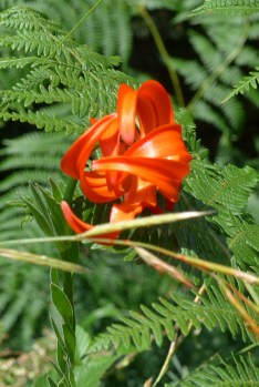
The path continues beside the wall, dropping down to cross a year-round stream before contouring on through lush oak and hornbeam woods dotted with hyacinths and wild strawberries. Look out for red-and-white helleborines in June, and the distinctive scarlet Heldreich’s lily in July.
At 1hr 55min you reach the start of the stone-built section – not much fun for vertigo-sufferers – with stupendous views over the foaming torrent beneath. Past a shrine on the corner (2hr 10min), the path becomes a broad ledge chiselled out of the rock face. After 10min, a second, rusting shrine signals the end of the tunnelled part. On the opposite bank, you can make out the path climbing abandoned terraces to cross the saddle R of a rocky fang.
At a small spur, the path winds steeply down L to reach the junction of the Asprórema stream with its tributary Skilórema (2hr 30min). An old concrete footbridge lies a further 100 metres upstream. Make your way up the stony bank to reach it, cross over and continue up the clear path zigzagging up beneath the rock fang, keeping the grey scree slope initially on your R. Cross it and climb to the base of the fang-rock, where you turn R and wind up past an obsolete telephone pole to the saddle (2hr 55min). Annoyingly, the path now descends – though more gently – passing the moss-covered trunks of evergreen oaks before flattening off slightly. Pass above a field with a fading wooden post pointing vaguely at the Kranoúla spring on the opposite riverbank.
Soon after you enter a grove of plane trees, cross a side stream and – less clear now – bear L before climbing to some 80 metres above river level. Cross another rocky outcrop at a saddle with a fir and stone shrine, then plunge back down to river level and keep a stone’s throw from the water. Around 3hr 40min you start to climb R away from the river, up a boulder-strewn gully delta, with only a green metal shrine as a pointer. Pick your way up crumbling terraces and meadows to a grassy flat top (possible campsite) with a ruined house L. The abandoned houses of old Asprórema are visible ahead. Climb a couple of terraces and resume NW to reach a second saddle with a pair of ruined houses. Between these a path descends to cross the Tsarkórema stream, which has water all year. Climb to a modern house (still occupied in summer) beside the shepherds’ track from Trováto and Tridhéndhro (4hr 15min).
BOX//Asprórema once had enough families to warrant a primary school, while the older children walked down to Epinianá every day for high school. The last family to quit permanent residence left in 1997. Ironically it was the arrival of the jeep track, aimed at making life easier, which allowed them to up sticks and move to the town of Agrínio on the coast, where the other villagers overwinter. A couple of families still return to these pastures with their flocks from June to October, when the track over the 1700m Tsoúka Sáka pass is open. But their houses are slowly crumbling.//END BOX
Turn L on the track that runs behind the modern house. Follow it up to join the main track and continue NW for about 30min, ignoring a L turn down to the Asprórema stream. Ford a stream and the little used track begins to climb. On the first R bend above the ford by a stand of fir trees you come to a once-substantial stone house (E00289028/N04340635; 1044m; 4hr 45min). Continue along the track passing a couple more abandoned but solid stone houses until it comes to an end at E00288704/N04341237; 1152m).
Leave the track and climb R up the earthy bank (E00288770/N04341472), then turn back L. The path is reasonably obvious, zigzagging up beneath big open firs to reach the three ruined cottages of Sfirí (E002887886/N04341453; 1301m). The firs are thinning out here. There are a number of overgrown and aged fruit trees, a sure sign of former habitation, but no sign of a water source.
Keep straight uphill from these ruins for a few minutes. For 20 to 30 minutes from where the trees end the path is very unclear in the unkempt grass and encroaching scrub. You need to get on to the spur directly above Sfirí. The old path seems to have swung out to the L before curving back R above a thicket of young firs and climbing up on to the spur from here. You reach the spur line at E00288991/N04341638 (1417m; 6hr 30min), clear of all the trees. The best thing for the moment may be to clamber directly up on to the nose of the spur from Sfirí, making your way as best you can; it should not take more than 20 to 30 minutes from Sfirí.
From here you continue up the ridge bearing NNE to the 1700-metre contour. The going is easier from here on; you are clear of the trees and traversing N and NNW across the flanks of point 2062m to reach the Delidhími col in around two hours, about 4hr total from Maria’s house (8hr 30min).
For Leondíto, drop down from the col almost due N, keeping to the spur that divides the two gullies opening below you. After about 10min you pass a water trough L and carry on down to meet a clear transverse path (E00288920/N04344500) crossing the grassy slopes just below the 1700m contour (9hr).
Turn L or W on the transverse path. Cross a dry gully and bear R along the opposite flank, then up and over a sharp little spur, cutting back L down a good rocky path on the W flank to the shallow gully below. Here, bear R and down to the shepherds’ hut at Lakómata (E00288364/N04344572; 9hr 30min).There is a spring here and it is a good place to camp if there are no dogs in residence.
From Lakómata, follow the track W for 30min beneath the distinctive horn-like peak of Salayiáni, passing a spring on the L, to a second sheepfold with a solid little cottage on a piece of level ground at the locality known as Mégas Stanós (E00287091/N04346821; 10hr).
Mégas Stanós makes a good campsite too, as long as there are no dogs in residence. A second advantage is that the shepherd who brings his sheep here in summer speaks very respectable English; his name is Yiánnis Makriyiánnis.
Bear R at the fork shortly after. The track contours N along the slope for about 600 metres, before zigzagging precipitously down into the woods at a locality called Niáles. At the bottom zigzag (10hr 30min), a disused track comes in from the gully to your R; this is an alternative route from Lakómata, marked on the map but very overgrown with bracken. From Niáles, continue down the track to arrive in Leondíto in about 1hr 30min (12hr).
Head N along the road from the square with its 900-year-old plane tree. On the L just past a walled spring and opposite the church (R below the road), a track cuts diagonally up L to some houses. Beyond the houses is an area of flat grassy ground, once a field, supported by a stone terrace wall. The path to the monastery of Spiliá follows along below the wall, bearing L ![]() and into the fir forest.
and into the fir forest.
The path to the monastery was obviously once a major route for pilgrims. For several years, the word has been that the path is impassable. If anyone tries to tell you that today, pay no attention. We cleared and marked the tricky second half in 2017!
It is an easy-going route, in and out of small gullies and over intervening spurs, sticking pretty much to the 900–1000m contour except for the last stretch where, from a natural belvedere at E00286054/N04349226, you gradually lose about 100 metres in height, dropping below the fir-line down into a deep little gully. Cross over by a large plane tree before climbing back R and steeply up through trees and across an expanse of stable scree. Just before you reach the monastery (Moní Spiliás; 13hr), spectacularly perched on a crag above the Koumbourianítikos river valley, you pass a wonderfully powerful spring. Do not miss a visit to the beautiful monastery church.
The monastery of Spiliá offers basic accommodation and meals for visitors. There are a couple of monks in permanent residence; you just have to bang on doors until you find them.
If you fancy a more comfortable and indulgent night, you can make your way down the monastery lane to the tarmac, turn right and walk down to Ta Ragázia, a welcoming, well-appointed magazeé right on the road below the monastery crag (Váïos Pózios: 24450-32020 and 24450-41140, mob 6979728262; open all year). It is a 30min walk.
